
August 29, 2018 — Upper Works
The Iron Works
The day began around dawn with some rough dirt roadways. Blue Ridge Road cuts nine miles from NY 28 to the “Upper Works trailhead” along Tahawus Road. Driving deeper into the forest, I considered just how isolated this corner of the Empire State truly is.
Isolated, and vast. Since the recent purchase of the Boreas Ponds Tract, the High Peaks Wilderness now boasts a contiguous land area larger than the City of Los Angeles. And surrounding the “wilderness” itself are miles of private and mixed-use forested lands devoid of connected, improved roads.
The sun slowly rose over the forests and marshes along the roadway. I passed the various remnants and active bits of the Tahawus mining area. Some say American Indians referred to Mount Marcy as Tahawus a word meaning “Cloudsplitter”. Like many of the best stories of Adirondack lore, it’s tough to pin down substantial evidence for this. But there you have it.
Upper Works refers to the ironworks that developed, albeit briefly, in this area of the high peaks. Among these works lies the massive McIntyre iron furnace, namesake of the MacIntyre Range I would soon hike.
The Headwaters
There are much more efficient ways to hike the MacIntyre Range trio of Algonquin, Iroquois, and Wright than from Upper Works. From the Adirondak Loj, you can make it a tidy day hike of manageable mileage. But I decided to turn these peaks into an overnight backpacking trip, setting up camp in the environs of Lake Colden. This would involve hiking Iroquois, Algonquin, and Wright via the steeper, southwestern approach.

I signed in at the trailhead and began the hike in, along Calamity Brook. The first moments of the journey were among the most auspicious. The trail crosses perhaps the smallest bridge spanning the mighty Hudson. The bridge sits mere yards from the Hudson River proper’s terminus at Henderson Lake. The Hudson flows a mile wide at points much further downstate. In New York City the massive George Washington Bridge stretches 4,760 feet from bank to bank. But up here at the headwaters, an unassuming concrete slab straddles the modest creek.
Soon after hitting the trail, you come upon a large monument to David Henderson. Henderson founded the McIntyre Iron Works and lends his name to the large lake at the Hudson’s terminus. Henderson came to an early demise in these environs, via stray gunshot. And hence “Calamity Brook” got its name. That about wraps up today’s history lesson.

The trail began in open marshland and tall grasses. It passed through pockets of pines and cedars. From there it entered mature, open-floored forest and slowly ascended roughly 1000 vertical feet along Calamity Brook. That brought me to the Flowed Lands.
The Flowed Lands and Lake Colden
The forested trail finally opens up into wide-open views upon reaching the Flowed Lands. A massive marsh/river hybrid gives the area its name. Here Herbert Brook, the Opalescent River, and Calamity Brook all mix together. These streams form the northernmost portion of the Hudson’s watershed. Off to the East, beyond the Opalescent, lies the river’s highest-altitude sources. Among them is Lake Tear of the Clouds, on the slopes of the Cloudsplitter itself.

From there I continued along a short and relatively flat stretch to Lake Colden. From the lake, you’re treated to dramatic views of Mount Colden. Colden’s massive slides often seem to steal the show from its larger and more famous neighbors, Marcy and Algonquin. Lake Colden also features some excellent (sought-after) camping spots.

Setting up a basecamp beneath the MacIntyre Range
This trip involved setting up a “basecamp.” I would drop most of my pack weight at my tent site. Then I’d continue fast and light to the summits and ridgelines. And so around mid-morning I made my way to a nice, secluded campsite along the Opalescent River. I put together my tent and sleep system. How luxurious it would feel to come back from a long hike to a bed ready and waiting!
This strategy meant I could start the day with way less water (and weight). After setting up camp, I filled my hydration pouch with freshly filtered water from the Opalescent. I stashed my bear canister. Then I prepped a much smaller “summit pack” and pressed onward towards the MacIntyre Range.


A sweaty scramble
My ascent was unfortunately timed to late morning. The midday sun began to really bake the thick piney woodlands. A swampy heatwave had settled into the broader northeast. And I had nearly 2000 vertical feet of hiking/scrambling along a small brook on Algonquin’s southwestern flank. That said, the ledges and pools of the stream occasionally afforded increasingly open views.

At some point, panting and scrambling my way towards the ridgeline, I managed to lose the trail. This was my second time getting a bit lost in the high peaks. And once more it occurred while traveling within the deceptive comfort of a streambed. I decided to press onward, up what I thought was the fall line. Soon I broke into an open, steep meadow area. The sloped clearing provided superb views of nearby Mount Colden’s signature slides.

Thoughts on slides
I stopped to admire this view for a bit. Among the Colden slides, one of the northernmost (leftmost in these photos) formed quite recently during Hurricane Irene. Its, smooth, bare bedrock appears noticeably lighter than the others. I sat there chomping on a protein bar and regaining strength. I thought about how mind-blowing that moment in recent history must have been.
That night involved torrential rain and cataclysmic flooding. At some point, an area of forest the size of multiple football fields just decided it couldn’t hold to the mountain any longer. And then quite suddenly, whole trees, and the dirt they had rooted through over many decades, and rocks and animals and logs and bushes and every other constituent of this unfortunate strip of woodlands just slid. It slid wholesale down the mountain and off the bedrock. Kaboom!
Since forming, the “Irene Slide” has apparently become a somewhat popular, if hair-raising ascent to Colden’s summit.

I’ve heard the smooth, exposed bedrock of the Adirondack slides is among the world’s oldest surface rock. The slabs date back roughly a billion years. It’s pretty rare to directly experience anything that’s been around for over 7% of the age of the universe.
I pressed on up through this meadow and then moving leftward (south) to try and regain the proper trail. I keep my phone in airplane mode, but this doesn’t prevent the GPS from receiving signals. This kept the blue dot well-synced on my cached topo map. With this, I quickly recovered the trail.
Boundary Peak
Hot and sweaty, I eventually gained the ridgeline. The deciduous forests surrounding Lake Colden had long ago given way to thicker boreal conifer woods. And those trees eventually grew stunted. And then the trees stopped as I approached the bare-summited peaks.
The entire journey from Iroquois to Wright takes place well above 4000’. And the majority of this MacIntyre traverse thus runs near or above treeline. This meant the prevailing winds provided a glorious, natural source of air conditioning. And that likely made this the least-miserable corner of the Empire State that sweltering day.
I headed southwest, towards Boundary and Iroquois peaks. A trailless “herd path” forms the route to Iroquois—unmarked and unmaintained by the DEC. But I found this route super clear and easy-to-follow, and devoid of any bushwhacking. Marshy areas feature good puncheon, presumably maintained by ADK. And cairns help guide you along stretches of bare rock. In fact, I thought this spur to Iroquois was better-maintained than most official trails.

I reached Boundary Peak, a small, non-high peak perhaps no more than 100 feet in prominence. This wide-open summit is among the tallest in the Adirondacks. From Boundary, the peaks of both Iroquois and Algonquin loom, in opposite directions.
Charles Brodhead, a surveyor of the late 1700s, was tasked with demarcating a line across much of the high peaks. The line crossed close to the summits and ridgelines of many peaks from Giant Mountain to Wallface. Boundary sits right along this survey line, likely providing its name. “Boundary” also seems appropriate as an homage to its two neighbors: Iroquois and Algonquin. The two American Indian nations had settlements abutting the Adirondacks. And the “dismal wilderness” itself thus forms an amorphous sort-of boundary between them.
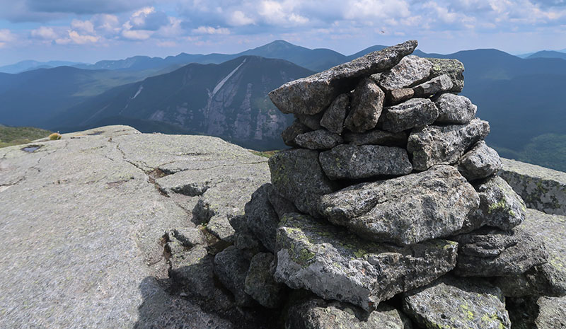
Iroquois (#18)
From there I traversed the ridgeline to Iroquois: the first of the day’s three official high peaks. Many folks do the MacIntyre trio as a day hike from the Loj. In that case, Iroquois typically comes last. Roping it into the mix only adds a couple hundred vertical feet of hiking.

Mighty Algonquin (#19)
After ambling back down Iroquois and over Boundary once again, I began the exposed ascent towards Algonquin. Algoquin ranks as the second-highest peak in the state. Only Marcy and Algonquin stand above 5000′ in elevation.
From the col to the summit, you ascend perhaps 400’. I found the climb both manageable and pleasant amidst a strong prevailing wind.
From the summit, I was struck by the commanding views in all directions. I could see Marcy and the Great Range and the usual suspects. But I also spotted points of interest unseen from most high peaks. Just to the west, I peered down towards Wallface and Indian Pass. To the north, I saw the town of Lake Placid with myriad buildings and farmland. Everything suddenly felt far less remote. I switched off airplane mode on my phone and discovered I had excellent service. A bit disappointing, but also a bit comforting. I decided to Instagram the moment.

Having negotiated a midweek retreat in exchange for working the following weekend, I had this very popular peak all to myself. To the east, the weather looked clear and stable. Only a few puffy white clouds dotted the sky. But to the west, I could see a wall of dark clouds approaching. I decided to press forward, quickening the pace.

Shifting weather atop Wright (#20)
The descent from Algonquin to the spur trail to Wright drops over 1000’. My original plan was to re-ascend Algonquin. This was by far the shortest-distance route to my campsite near Lake Colden. But with storm clouds on the horizon, I wasn’t sure that was safe.
I ascended the 400-foot plus spur to Wright peak. The views from Wright’s open summit were excellent. But the day’s foray onto Algonquin had really spoiled me into feeling kinda blasé about it at this point.
More important, I was in search of the famous “plane wreck” atop Wright. This was, unfortunately, an example of expectations not meeting reality. My hopes involved finding the remains of a full airplane. I pictured it suspended, askew, amidst the trunks of large trees. I imagined massive vines hanging down from its wings and engines. Inside: snakes. Instead, there was a plaque and some rusted bits of metal plane detritus. Underwhelming.
Interestingly enough, there’s a second plane wreck in the MacIntyre range. And this crash comes much closer to fulfilling my Indian Jones-style expectations. That wreckage is located further south, in the col between Iroquois and Marshall. Marshall forms the fourth, orphaned high peak of the range. I had yet to visit that wreck, but it was on my agenda when I finally hiked Marshall.
Just as I began my descent, the storm clouds from the west arrived on Wright. Thunder boomed, and suddenly the sky burst into heavy rain. I pulled my rain shell out of my day pack and took off for treeline.

The long march to camp
As I reached the main trail I had a choice. I could re-ascend Algonquin, climbing 1000 vertical feet in a rainstorm. Or I could continue down towards the Adirondak Loj, under the cover of trees. This would mean ascending into Avalanche Pass and then back to Lake Colden. This latter route added miles to my hike but was arguably safer in a thunderstorm. I elected to continue downhill.
Thus began a long, slow slog around a massive loop. The trail brought me within spitting distance of the Heart Lake trailhead. Then I hiked back in towards Marcy Dam, up to Avalanche Pass. Then came the endless ladders and boulder scrambles of Avalanche Lake. Somewhere after Marcy Dam, the sun dropped below the mountains, and out came the headlamp. My second big Adirondack Death March was well underway. I finally made it back to camp well after 9 pm. The rain was long gone, but now I had the regrettable task of cooking and eating dinner in total darkness.
The blast furnace
In the morning I made some oatmeal, broke camp, and began the several-mile hike out. I trudged back out through the Flowed Lands, along Calamity Brook, and over the Hudson to Upper Works.
Driving out, I stopped along the roadway at the old blast furnace of the McIntyre Iron Works. I was struck by just how massive the blast furnace was. The stone tower was itself just a small remnant of a massive, mostly wooden structure adjacent to the Hudson. The iron mined here was laced with a mysterious impurity that would halt operations just a few decades after they had begun. That said, the mines would see renewed life nearly a century later, circa World War II. And all thanks to a need for that same “impurity”: titanium.
Seeing the McIntyre blast furnace seemed a fitting conclusion to my foray into the MacIntyre range. Just one of many adventures in the storied High Peaks Wilderness.