
March 7, 2020, Adirondak Loj
Arrival
The journey to Mount Marshall began on a largely ordinary weekend in early March of 2020. It was likely the last ordinary weekend of 2020. The novel coronavirus had already begun to increasingly dominate the news cycle. But that was hardly evident on this sunny, beautiful Saturday. Alpine and nordic skiers, snowshoers, and post-holers had already filled the parking lots of Heart Lake. Between the rows of cars, excited conversations took place in both French and English in equal measure. There’s usually one (maybe two) weekends in March where the bright sunshine of nearly-spring and the thick snowpack of a full winter collide. This was that weekend.
I set off along the trail to Marcy Dam. The days were growing longer and at 7 am the Sun was already high in the sky. Roots and rocks were just barely poking up beyond the snowpack at these lowest elevation sections of trail. But the temperature remained well below freezing and the snow remained in great shape for the many cross country skiers.
An hour or so later I arrived at Marcy Dam. A fully frozen bridge of ice and snow allowed everyone to simply walk across the brook just upstream of the dam remains.

Frozen lakes en route to Beaver Point
I expected this weekend to mark my last adventure from the Adirondak Loj into the High Peaks wilderness. The plan was as follows: hike to the Beaver Point lean-to on Lake Colden that day, set up camp, and tackle Mount Marshall. The following day, I’d use that position deep within the central high peaks to tackle Cliff and Redfield, before breaking camp and hiking back out to the Loj. That was the plan, at least.
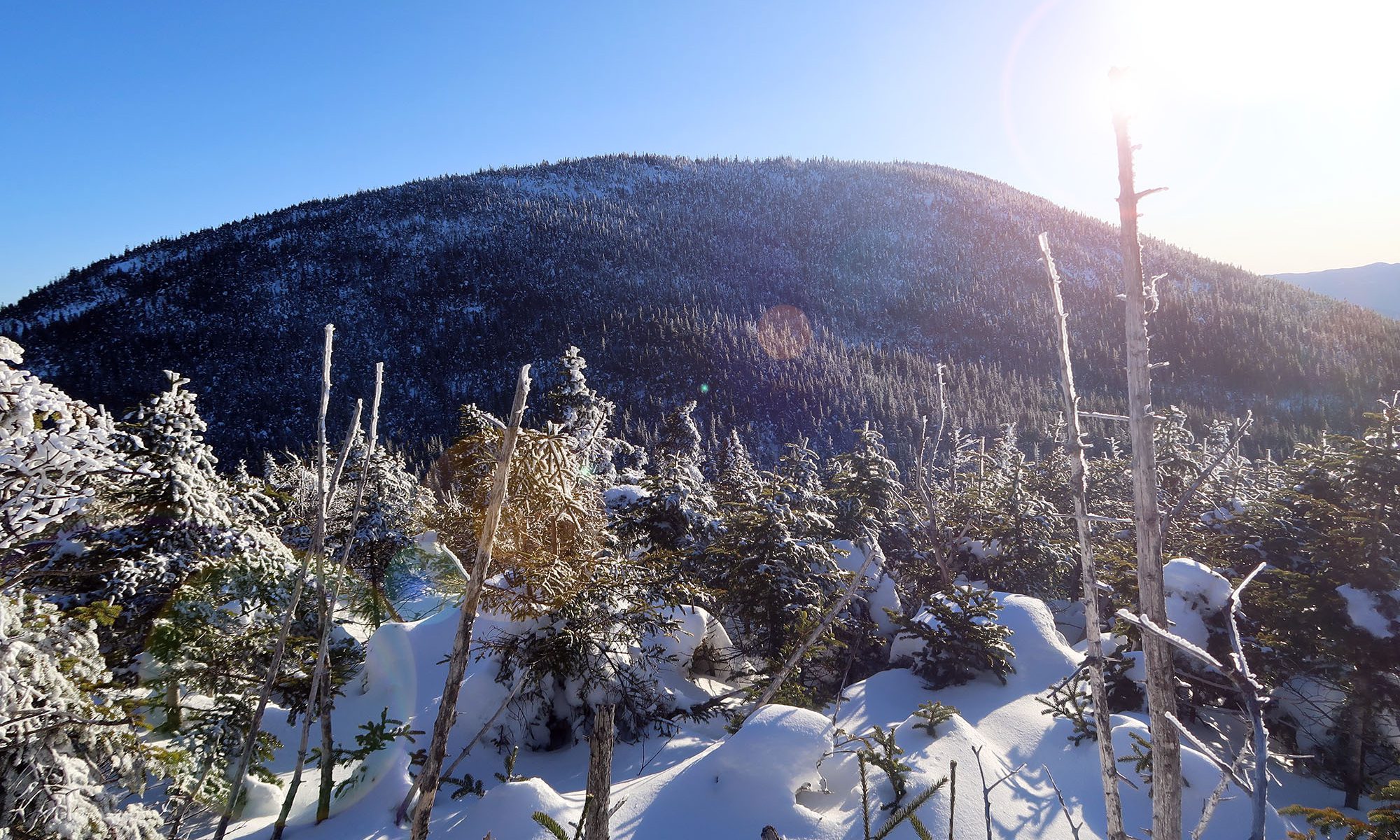
A few miles of woodland later, I arrived at the dramatic corridor of Avalanche Lake. I last ventured through this stunning landscape (night hiking, excepted) on my first high peaks adventure three years earlier. The frozen landscape stood in stark contrast to that sweltering July day.


I bypassed the ladders and boulders and famous Hitch Up Matildas in favor of simply walking across the frozen lake. With a full pack of winter camping gear on my back, this was a welcome reprieve. I had rented a truly massive -20F sleeping bag and insulated pad from EMS in Lake Placid the day before, and my pack clocked in somewhere around 45 lbs that day.
A short while later I arrived at Lake Colden, where a frozen surface likewise made for a speedy passage to the excellent Beaver Point lean-to.

After setting up camp in the beaver point lean-to, it was now mid-Afternoon. I knew this was a late start for a summit attempt. But the days were growing longer and Marshall was only a bit over 1000 vertical feet above Lake Colden. I figured everything was fine.
Mount Marshall (first attempt)
The ADK trail map for the high peaks region marks at least one herd path to the summit of every high peak. But as of the 2015 edition I knew it omitted some common alternative herd paths. For example, the map omits the Santanoni Express, an awesome and efficient alternative to a two-way approach along the path from Bradley Pond.
Having discovered that gem, I felt emboldened to try Marshall from Cold Brook Pass. The DEC stopped maintaining this trail following Hurricane Irene, but as of 2020 it was re-sanctioned as an official trail. The herd path from the col to Marshall’s summit did not appear on my map, but it did exist on All Trails. Taking this approach would turn my afternoon into a loop instead of an out-and-back. It would also feature visiting a sweet airplane wreckage.
I began to ascend towards Cold Brook Pass. Soon enough I was 1000 vertical feet above Lake Colden. I peeled off the trail just before the col, to a spot south of the path where All Trails told me the small airplane would be. I saw nothing. Then I noticed a small bit of rusty metal on the “ground” and began to dig into the deep snowpack. It was hollow!
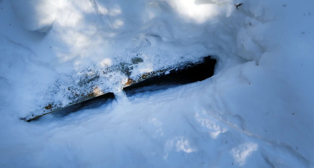
The submerged wreckage left me a bit disappointed, but I powered onward towards the summit. As it gained altitude, the herd path afforded sweet views of Shepard’s tooth, a small rock outcropping on Iroquois’ northern flank. Unfortunately complications arose that distracted me from getting any great photos.
Deep snow on Mount Marshall’s false summit
As I approached the auspicious 4000′ mark, the herd path became harder and harder to follow. Winds had deposited deep layers of fresh snow around a false summit just north of the peak. My snowshoes began to sink multiple feet into these snowbanks. Travel grew slower and more arduous. I doubled back several times. The sun went lower and lower in the sky. Over an hour passed.
Eventually, I reached the false summit. Marshall stood just a quarter mile or so south of where I stood. It looked beautiful in the late afternoon light.

The urge to press onward was so tempting. My day began nearly 10 hours ago, and I’d yet to bag a single peak. It was so close, visible ahead of me. But I knew the day was growing late. I knew that quarter mile of bushwhacking could easily take over an hour. I knew I needed energy to make dinner and stay warm and fuel my body through a very cold night. So with a heavy heart, I turned around and began the descent to camp.
This was the correct decision. Even as I approached the col, the sun sat low in the sky. By Lake Colden, night had arrived in the mountains.


A winter night
I arrived at camp for dinner. Shortly thereafter, a young couple from Quebec joined me at this ordinarily very popular lean-to. As we all settled in, my mind went to COVID-19 for the first time that day. I thought about how curious it was, a young man from Brooklyn making close contact with a couple from Montreal deep in the woods of the Adirondacks. What if this was some crucial link in the chain of infections? What a strange and unlikely journey from a wet market in China.

41 summits into my High Peaks journey, there was still room for “first times”. This night marked my first time winter camping. It was cold. A whole flock of geese feathers swaddling my body kept me toasty warm (sweating even), on average. But the mediocre sleeping pad left my hip, shoulder, and thigh freezing. I was beginning to deeply regret my side-sleeping habits. Nonetheless the days’ trials knocked me out cold within the hour.
Mount Marshall (#42)
I awoke the next morning refreshed. The temperature had spiked overnight and morning at camp was not completely miserable. I decided to nix Cliff and Redfield and simply re-tackle Marshall that day.
As I began up the conventional herd path, I thought about the prior afternoon’s misadventures. The lost/bushwhacking experience seemed appropriate for this of all high peaks.
Mount Marshall was named after Robert Marshall, one of the three original Adirondack 46ers. Bob Marshall loved surveying maps and taking long walks deep into the Adirondacks. Together with his brother and their guide, Herbert Clark, he set off to ascend the 46 peaks they identified from those maps as 4000+ feet tall, sufficiently prominent and sufficiently isolated. That journey began in 1916, over 100 years ago. Today, nearly 12,000 46ers (and counting) have followed in their footsteps. Bob went on to serve in the federal government, at the cabinet level with FDR, and was an early and strong advocate for the preservation of wilderness nationwide.

It’s hard to imagine how much more daunting the task must have seemed back then. There was no memorial highway to the summit of Whiteface. They were largely unaided by herd paths, and ranger condition reports and GPS devices and Sawyer Squeeze filters. It was just three men bushwhacking across vast swaths of forest towards summits both famed and ignored.
Eventually, I reached the summit of Mount Marshall. The views of Colden, Marcy and the McIntyre Range did not disappoint!

Back to civilization
I descended Marshall, packed up camp at Beaver Point, and began the slow, heavy slog back to Heart Lake. The day was hot, and the snow reflected the bright sun right back into my face. It was a weekend of weather extremes.
Usually the last miles of a backpacking adventure feel like you’re coming back to safety and comfort. Civilization (and cell service) are just moments away. But as the world began to turn to the daunting task of mitigating a global pandemic this sense seemed to flip on its head. I was now hiking from a place of pristine beauty and simplicity to a very completed situation. Who knows what headlines would light up my phone as I switched off airplane mode. To me, these thoughts emphasized the importance of wilderness and places like the High Peaks. The virus would come and go and the world would be changed forever. But the wilderness would remain, ready to be explored.
